Welcome to Bishop Falls, New York, in summertime 1905. You may have seen it on the postcards. It’s an iconic, multi-tiered waterfall reminding some of a miniature Niagara. There’s a bustling mill taking a slice of the frothy waters to churn out flour to help feed citizens. Nearby in swimming holes are bathing tourists escaping New York City’s summer heat, and rooming in local boarding houses.
And just downstream is a covered bridge and a scenic rocky gorge through which the Esopus Creek rushes, meandering on through a valley that is soon to be submerged.
More than a century later, the cliffs that once hosted Bishop Falls are dark, caked in sediment, and more than 100 feet underwater.
The Esopus was dammed in 1914 for the Ashokan Reservoir to supply water to a growing metropolis downstate. Bishop Falls and surrounding hamlets, most in the town of Olive, were forced out of existence or forced to relocate through eminent domain.
In all, about 2,300 people were relocated, more than 500 buildings moved or demolished, 11 miles of railroad track rerouted, and 32 cemeteries moved to make way for the Ashokan Reservoir, about 10 miles west of Kingston in Ulster County.
“The generational trauma is still kind of reverberating,” said Kate McGloughlin, an artist, resident of Olive, and a descendant of many of the displaced residents, including the Bishops and Boices who ran the mill complex at Bishop Falls.
‘Ugly’ battle for compensation
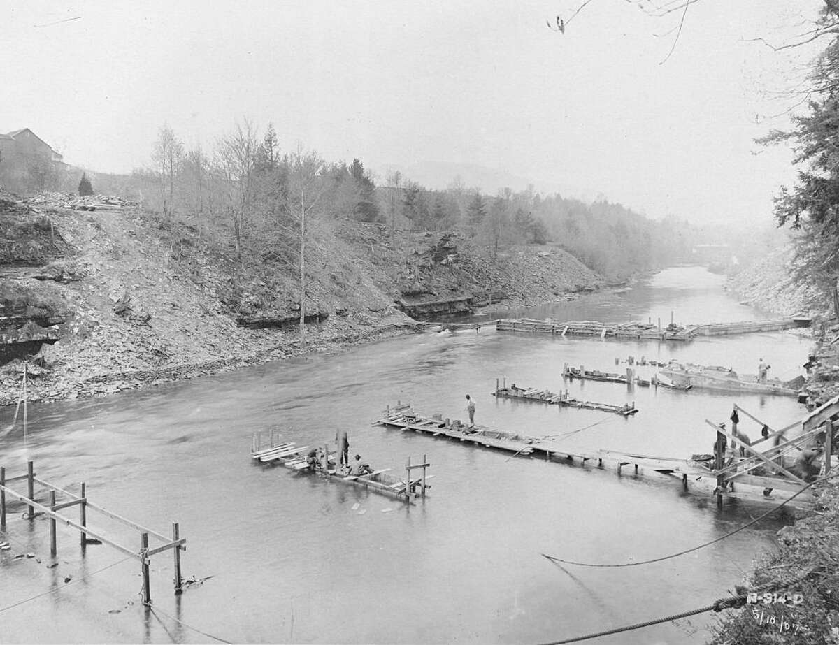
Thousands of people were relocated and hundreds of buildings moved or torn down to make way for the Ashokan Reservoir, about 10 miles west of Kingston in Ulster County. This photo, taken in 1907 at the Olive Bridge Dam, shows coffer-dam and piers under construction for supporting the 8-foot pipes to carry the flow of water in Esopus creek.
Smith Collection/Gado via Getty ImagesThe reservoir allowed New York City to continue growing in population in the early 1900s. Today about 40 percent of the city’s drinking water flows from it and through the New York Aqueduct, according to New York City’s Department of Environmental Protection (DEP).
Now, as the DEP prepares to embark on a billion-dollar Ashokan Century Program to upgrade the reservoir’s 100-year-old infrastructure, the old, inter-generational wounds remain largely unhealed.
According to Frank Almquist, author of the book “Building the Ashokan Reservoir,” there are local residents who will avoid driving along the reservoir out of resentment for what they say New York City did to their forebears.
“It didn’t have to be quite as ugly as it was,” said McGloughlin, who said her family was largely underpaid for their 14 properties to make way for the reservoir. She explored that trauma through her 2018 multimedia exhibit “Requiem for Ashokan.”
“It’s bad enough to rip up the landscape and displace people but to disrespect them so much and pay them so little,” she said. “Some people got a chunk of money even though it was below market value, but most people didn’t. Most people got really hosed on this. And the qualitative thing that nobody can quantify is this trauma, this displacement, this weirdness that happens. Basically they tore the heart out of our community.”
Related: Proposed hydroelectic plant near Ashokan Reservoir shifts location after stiff opposition
Dr. April M. Beisaw, an archeologist and Vassar College professor, has for the past decade been studying the anthropological impacts of New York City’s quest for water. She and Almquist said they believe residents at the time were not fairly compensated overall.
“I’ve encountered people over the years who say that,” said Adam Bosch, director of public affairs for the DEP’s bureau of water supply. “And that may be the truth — that in some cases the city underpaid.”
But the opposite is true, too, he said. “There are people I’ve met over the years who have said their families were paid fairly. There are people I’ve met who say their families couldn’t believe how much money they got for their property. So, there are different feelings about the takings from a hundred years ago.”
Forcing the Catskills to bend to the needs of the city
“The generational trauma is still kind of reverberating,” said Kate McGloughlin, an artist, resident of Olive, and a descendant of many of the displaced residents. She created a body of work, “Requiem for Ashokan,” that explores the loss of these communities.
Kate McGloughlinAccording to David Stradling, a history professor at the University of Cincinnati and author of the book “Making Mountains: New York City and the Catskills,” the truth on that matter swings heavily based on perspective.
Stradling’s research for his book, which included in-depth reviews of the state-ordered commission’s hearings on land takings, showed that by the end of 1932, when most cases had been settled, “The commission had heard 755 cases, with a total of over $10 million in claims. They had awarded a little more than $1.4 million to claimants.”
Stradling said the hearings were trial-like, during which both New York City officials and landowners could call on witnesses. The commission was composed of one person from Ulster County, one person from New York City and one person from elsewhere in the state, Stradling said.
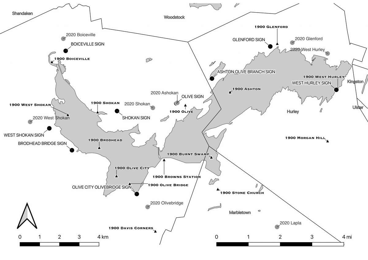
A map created by Dr. Beisaw indicating the site of the hamlets in the 1900s versus present day, and how they relate to the former site markers along the reservoir.
April M. BeisawEven with the wide gulf between the millions claimed and the fees the city paid, Stradling said,“My sense was that the lawyers representing the local folks did an outstanding job. I think in general the city paid much more per acre than people would have gotten in the open market had there never been a conversation about building the Ashokan Reservoir.”
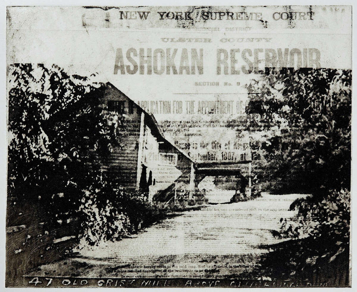
Stradling has written specifically about the Bishops, who owned more than 100 acres around Bishop Falls. Valuing their property was challenging because it surrounded this significant tourist attraction, which was called the “Gateway to the Catskills” by Harper’s Weekly. But also, he pointed out, many people had no interest in selling or leaving their home.
“If you aren’t expecting to have your property on the market, then the market value has nothing to do with how you think about it. It wasn’t a process [locals] wanted to go through. I think that’s where the built-in tragedy of the story comes in,” he said.
“It’s not New York City stealing things from the country in that kind of overt way. It’s the larger process by which the importance of New York City forces the Catskills to bend. Because everybody knows that you have to supply water to New York City. It’s a much larger imbalance of power between the city and country than just those courtroom proceedings.”
Remembering the lost hamlets
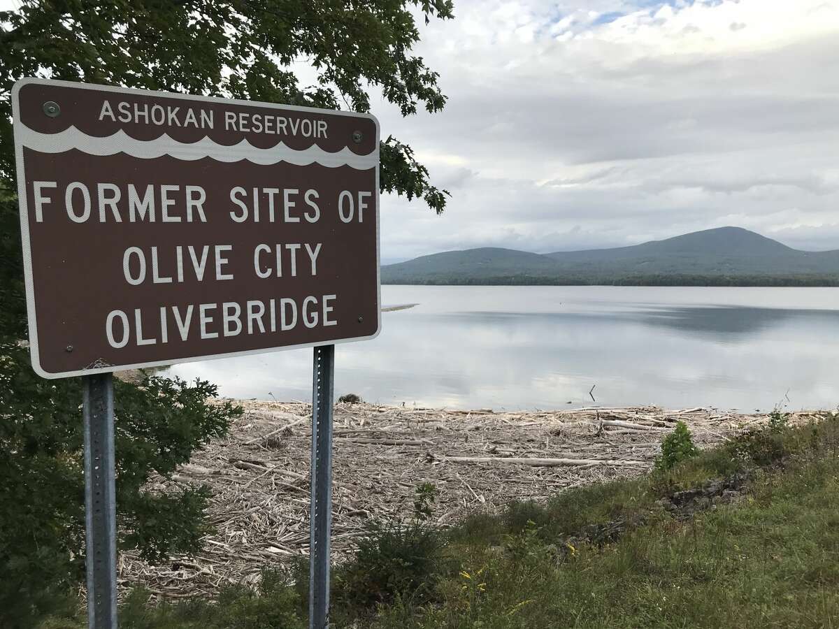
Brown signs visible to motorists along Route 28 and Reservoir Road list the former sites of the hamlets submerged in the making of the Ashokan Reservoir.
Billy ShannonThe hamlets that existed before the Ashokan Reservoir were laid out in a zig-zag pattern through the Esopus Valley, each roughly five miles apart, according to Almquist. He described the displaced hamlets, some of which were settled in the 1700s, as self-sufficient communities that produced a lot of milk taken by train to Kingston.
Local residents produced harnesses and tanned hides, ran cider mills and orchards and quarried a lot of bluestone used for sidewalks outside the area, he said.
Around the reservoir — which Almquist, a retired IBM engineer, ranks among the top engineering feats in human history — are brown signs visible to motorists along Route 28 and Reservoir Road that list the former sites of the hamlets. As Beisaw points out, though, not all of the signage has been placed in the exact locations of the old hamlets.
Roughly 10 to 12 communities were displaced in all, though historians diverge on the exact number. Four shifted boundaries and exist today in the (new) town of Olive: West Shokan, Boiceville, Shokan and Olivebridge. Others nearby also relocated, like West Hurley. Ashton and Brown’s Station were abandoned.
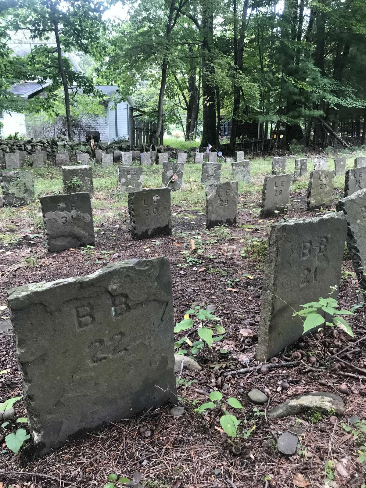
Dr. April M. Beisaw, an archeologist whose book “Taking their Water for Our City: Archaeology in New York City Watershed Communities” will be published next year, believes the 285 headstones that bear no names at Bushkill Cemetery in West Shokan deserve interpretative signage to explain what happened to these displaced gravesites.
Billy ShannonAsked whether any of the Century Program funds are earmarked for recognizing people who were displaced to build the reservoir in the early 1900s, Bosch said the DEP is open to incorporating a remembrance of the hamlets’ residents into the improvements planned for the J. Waldo Smith Monument, which commemorates the lead engineer of the reservoir.
Local residents in the past have called for New York City to pay higher taxes for the reservoir buffer lands acquired in recent years, and to use those funds locally to pay for a center to benefit the community. Suggestions include a new municipal athletic center to make up for the one McGloughlin said existed prior to the reservoir, or a home for the Olive Historical Society.
The lost hamlets remain a topic locals are interested in remembering. On Sept. 18, a new exhibit opened at the Olive Free Library in West Shokan called “Our Lost Community: Life Before the Reservoir.”
The exhibit, which runs for six months, features ledgers, maps, deeds and numerous photos of the old hamlets.
Honoring the final resting place of the displaced
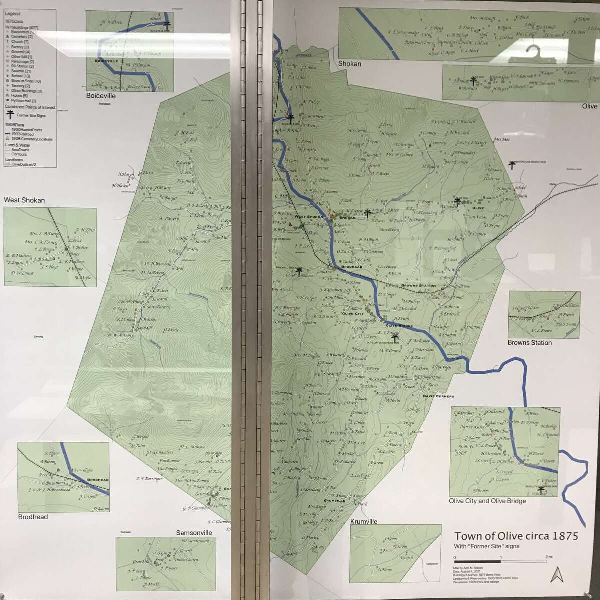
The Olive Free Library is hosting an exhibit, “Our Lost Community: Life Before the Reservoir,” featuring ledgers, maps, deeds and numerous photos of the old hamlets. Dr. Beisaw contributed this map of the original location of the hamlets displaced and destroyed in the making of the reservoir.
Olive Free LibraryEminent domain requires people to uproot and move, and this disruption applies to those who have been laid to rest, too. While 3,000 buried people were relocated to make way for the Ashokan — with New York City’s Board of Water Supply offering $15 per moved grave, or about $400 in today’s dollars — there were 285 graves whose families or ancestors did not arrange to have moved.
These 285 graves currently rest at Bushkill Cemetery in West Shokan, each bearing a simple numbered headstone and no name.
“To me it’s a mass grave, because mass graves are anonymous,” said Dr. Beisaw, who has finished a book due out next year through Berghahn Books titled “Taking their Water for Our City: Archaeology in New York City Watershed Communities.”
Plastic flowers or flags adorn roughly 15 percent of the gravesites though, she said.
“So therefore some people know who these people are, yet it’s an anonymous cemetery to outsiders. Which to me is serving to hide the horrors of what happened.”
At the very least, the plot should have signage contextualizing who is buried here and and the sacrifices they represent, she said, as Massachusetts has done to commemorate gravesites uprooted by the construction of the Quabbin Resevoir.
“If you pair those two,” she added, “what New York has done versus what Boston did — one is owning what has happened and the impact on the future communities and the future family members. And the other is hiding what has happened.”
More Hudson Valley History
Credit: Source link